Search

Showing total 187 results

Search Constraints

Start Over You searched for: Topic canada Remove constraint Topic: canada Publication Year Range More than 50 years ago Remove constraint Publication Year Range: More than 50 years ago Database LUNA Commons Remove constraint Database: LUNA Commons
187 results

Search Results

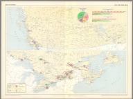
1. (63) Pulp and paper mills : (Pulp and paper mills in Western Canada) -- (Pulp and paper mills in Eastern Canada). Compiled from information supplied by the Forestry Branch, Department of Northern Affairs and National Resources. (Canada Department of Mines and Technical Surveys.)

2. (Text Page to) (63) Pulp and paper mills : (Pulp and paper mills in Western Canada) -- (Pulp and paper mills in Eastern Canada). Compiled from information supplied by the Forestry Branch, Department of Northern Affairs and National Resources. (Canada Department of Mines and Technical Surveys.)

3. (Facsimile) Map of Western Part of the Dominion of Canada (portion) to Accompany a Paper by Wm. Ogilvie. Scottish Geographical Magazine, 1898. The Edinburgh Geographical Institute. J.G. Bartholomew. Alaskan Boundary Tribunal, 1903. 46. Andrew B. Graham. Photo-Litho. Washington.D.C.

4. (Facsimile) Papers _ Hudsons Bay Company. Map of North America. Photo. Lith. by A. Hoen & Co. Baltimore, MD. No. 542. Ordered by the House of Commons to be Printed 12th. July 1850. Henry Hansard, Printer.

5. Canada. Drawn by A. Arrowsmith. Engraved by Sidy. Hall. Published, 1817, by A. Constable & Co. Edinburgh.

6. Wyld's Sketch of the Country Around Montreal, Shewing the Villages & Military Positions. London, Published by James Wyld, Geographer to the Queen, Charing Cross East, Der. 28th 1837 ... Day & Haghe Lithrs to The Queen, Gate St.

7. Amerique Boreale, Nouvle. Bretagne & Canada. Atlas spheroidal & universel de geographie dresse par F.A. Garnier, geographe. Ve. Jules Renouard, Editeur, Rue de Tournon, no. 6, Paris. 1860. Impie. de Louis Antoine, 1, Rue de Cluny, Paris.

8. Amerique Russe, et partie des regions polaires boreales. Atlas spheroidal & universel de geographie dresse par F.A. Garnier, geographe. Vve. Jules Renouard, Editeur, Rue de Tournon, no. 6, Paris. 1860. Imp. Sarazin, r. Git-le-Coeur, 8, Paris.

9. Canada. Neele sculp. Published Jany. 1st. 1819, by Pinnock & Maunder Strand.

10. Britische Nord-America. Gezeichnet nach aufnahme der hudsons-Bay-Compag, Parry, Franklin, Beechy, Graab, J. Ross & Back; vom Haupt. Radefeld. 1852. Stahlstich (Direction v. Kleinknecht). (In upper margin) Meyer's Groschen Atlas. (to accompany: Meyer's Zeitungs und Groschen Atlas aller Lander und Staaten der Erde).

11. A New Map of Maine. Published By S. Augustus Mitchell, N.E. corner of Market & 7th Streets, Philada. Entered according to Act of Congress in the 1846, by H.N. Burroughs, - in the Clerk's Office of the District Court of the Eastern District of Pennsylvania. 6.

12. Canada West, formerly Upper Canada. Published By S. Augustus Mitchell, N.E. corner of Market & 7th Streets. Entered according to Act of Congress in the 1844, by H.N. Burroughs, - in the Clerk's Office of the District Court of the Eastern District of Pennsylvania. 4.

13. Canada East, formerly Lower Canada. Published By S. Augustus Mitchell, N.E. corner of Market & 7th Streets, Philada. Entered according to Act of Congress in the 1846, by H.N. Burroughs, - in the Clerk's Office of the District Court of the Eastern District of Pennsylvania. 3.

14. North America. Philadelphia, Published By S. Augustus Mitchell, N.E. corner of Market & 7th Streets. 1848. Entered according to Act of Congress in the 1846, by H.N. Burroughs, - in the Clerk's Office of the District Court of the Eastern District of Pennsylvania. 2.

15. Georgia Strait And Strait Of Juan De Fuca, Washington ... Published Oct. 1898, H.S. Pritchett, Superintendent. Verified: O.H. Tittmann, Assistant in charge of the Office. Gershom Bradford, Assist. and Hydrographic Inspector. United States Coast And Geodetic Survey. Treasury Department ... Corrections from Corps of Engineers, U.S.A., to 1900 ... Electrotype Copy No. 1 U.S.C. & G.S. 6300.

16. North America. Drawn by Wyld. Engraved by Hewitt. Published by John Thomson & Co. Edinburgh. (to accompany) A General Atlas, Containing Maps illustrating some important periods in Ancient History; and distinct Maps of the several Empires, Kingdoms and States In The World, From Original Drawings according to the latest Treaties by J. Wyld and Engraved by N.R. Hewitt. Edinburgh, Printed for John Thomson & Co for Baldwin, Cradock & Joy, London & John Cumming, Dublin.

17. Political Map Of The United States, Mexico And The British Provinces. Adapted To Woodbridge's Geography. Engraved by J. M. Atwood. N. York. Entered .. . 1845, by W.C. Woodbridge ... Massachusetts. Hartford. Published By Wm. Jas. Hamersley. (inset) Map of Railways & Canals In the Middle States. (inset map) Michigan, Wisconsin, Iowa, Minesota. (Inset map) District Of Columbia.

18. Political Map Of The United States, Mexico And The British Provinces. Adapted To Woodbridge's Geography. Engraved by J.M. Atwood. N. York. Entered ... 1845, by W.C. Woodbridge ... Massachusetts. Hartford. Published By Wm. Jas. Hamersley. (to accompany) Modern Atlas, Physical, Political And Statistical; Exhibiting On Separate Maps ... (inset) Map Of Railways & Canals In The Middle States. (inset map) Michigan, Wisconsin, & Iowa. (inset map) District of Columbia.

19. United States And British Provinces. (engraved by) Perkins & Heath. London. Published by Whittaker, Treacher & Arnot.13 Ave-Maria-Lane, London. . (to accompany) Modern Atlas On A New Plan; To Accompany The System Of Universal Geography, By William Channing Woodbridge. Includes: Reference to Cities. Seats of Government. Large Town. Small Towns. Figures 1. 2. 3. &c refers to Classes. Colleges. Principal Roads. (note) The Western U.S. Territory extending to the Pacific Ocean is inhabited exclusively by Indians and Traders.

20. Plan de L'Île de St. Jean

21. Carte Réduite des Côtes Orientales de L'Amérique Septentrionale contenant Celles des Provinces de New-York et de la Nouvelle Angleterre, celles de l'Arcadie ou Nouvelle Ecosse de l'ile St. Jean avec l'intérieur du Pays

22. British North America (Dominion Of Canada And Newfoundland). Constructed From The Recent Government Publications & Other Most Authentic Material By W. & A.K. Johnston, Geographers; Engravers & Printers to the Queen, Edinburgh, And London. 1882. Railways Added To 1893. Engraved & Printed by W. & A.K. Johnston, Edinburgh & London. Entd. Stationers Hall, all right of reproduction reserved.

23. Nordamerika : Ubersicht des Relief und der Politischen Gliederung. Gotha : Justus Perthes. Sydow-Wagners method. Schul-Atlas. XXII.

24. Nordamerika : Sonderkarten zur Landerkunde. Gotha : Justus Perthes. Sydow-Wagners method. Schul-Atlas. XXII.

25. Williams' Copper - Plate Map Of The United States, Canada, Mexico, Central America, West Indies, &c. Published by John M. Atwood, 402 Locust Street, Philadelphia. Printed by F. Bourquin, 31 So. 6th Street, Phila. Copyright 1876 by G. Washington Williams.

26. Nordamerika : Sonderkarten zur Landerkunde. Gotha : Justus Perthes. Sydow-Wagners method. Schul-Atlas : 21 Auflage. 1940.

27. Nordamerika : Ubersicht des Relief und der Politischen Gliederung. Gotha : Justus Perthes. Sydow-Wagners method. Schul-Atlas. XXI.

28. 'I'm entirely surrounded by admiring water.' Newfoundland. Luxor Price. (to accompany) The Magic Map, by Mary Graham Bonner, Illustrated by Luxor Price. New York, the Macaulay Company. Copyright, 1927.

29. Carte generale des Etats Unis de l'Amérique Septentrionale, par A.H. Brue ... A Paris 1824, Chez l'Auteur, 1824. (to accompany) Atlas physique et politique des cinq parties du monde, par H. Brue.

30. Lloyd's New County Map of the United States And Canadas showing Battle Fields, Railroads, &c. Compiled From The Latest Government Surveys & Other Reliable & Official Sources. Published by H.H. Lloyed & Co. 81 John St. New-York. 1863. Drawn And Engraved By Schonberg & Co., New York. Entered ... 1863, by H.H. Lloyd & Co. ... New York. Published By H.H. Lloyd & Co. ... B.B. Russell, 515 Washington St., Boston, R.R. Landon, 88 Lake St., Chicago ... (inset) California, Oregon And The Territories Of The United States ... (inset) Part Of Florida.

31. Canada

32. Kanada. Československý vojenský atlas̊.

33. Kanada, Aljaška, Gronsko. Československý vojenský atlas̊.

34. Lower Canada, New Brunswick, Nova Scotia &c. / drawn & engraved by T. Ettling, 3, Red Lion Square, Holborn ; E. Weller, Lithogr.

35. Upper Canada / drawn & engraved by T. Ettling, 3, Red Lion Square, Holborn ; E. Weller, Lithogr.

36. (Outline map of Canada) .جغرافیای عمومی اطلسی = Atlas of general geography. Istanbul 1300 (1923).

37. Correct glass grid superimposed on photo. Topographical Survey of Canada -- Compilation from opposite photograph.

38. Map of Canada : Areas in Canada covered by aerial photograhps taken prior to July 1st 1926, shown in red. O.R. 302. Ordnance Survey, 1926. Printed at the War Office, 1926.

39. (Covers to) Road atlas : Supplement to Rand McNally commercial atlas service. Rand McNally & Company, Publishers, New York, Chicago, San Francisco.

40. Geographie commercial et industriel : Nouvelle carte illustree de l'Amerique du Nord : indiquant les grandes divisions physiques, la distribution geographique des vegetaux et des mineraux, les ports de commerce, villes industrielles et fortifiees des differents etats. Dressee par A. Vuillemin. Gravee par Langevin. Paris, Chez Fatout, Editeur. 1857. Grave sur acier, la topographie par Gerin, le trait au burin par F. Lefevre, Les illustrations dessinees par A. Testard et gravees par Guesnu. Imp. par Mangeon. Paris. (to accompany) Atlas de geographie commercial et industriel.

41. British possessions in North America. (to accompany) Atlas Modern. (The Cyclopedia; or, Universal Dictionary of Arts, Sciences, and Literature. 41 vol, 6 vol. of Plates, Ancient and modern atlas.)

42. Sev. Amer. Soyedinennyye shtaty, Meksika i Yuzhnaya. Kanada : Ekonomicheskaia karta. Prof. M. I. Silishchenskiy. 'Geokartprom' Typo-Lithography and M.T. Dunaeva, Moscow. (to accompany) Geograficheskiy atlas Chast 1.

43. Map of the British Province of New Brunswick from the best existing material : by authority of the Provincial Legislature with adjacent parts of Canada, Nova Scotia, and Maine. Compiled and drawn by John Wilkinson. Surveyor and Civil Engineer ... 1858. (inset) Chart (on Mercator's projection) shewing the relative geographical position of New Brunswick and of the several provinces forming part of British America, with the shortest sailing distances to the British Islands.

44. Petermann : Vereinigte Staaten Von Nord-Amerika In 6 Blattern, Bl. 3. Bearbeitet v. H. Habenicht. Gest v. Eberhardt, Kuhn, Metzeroth & Weiler. Stieler's Hand-Atlas No. 83. Gotha: Justus Perthes. 1875.

45. Nord-America. Entworfen u. gezeichnet von F. von Stulpnagel. Gest v. W. Behrens. Stieler's Hand-Atlas No. 79. Gotha: Justus Perthes. 1875.

46. Verein-Staaten Von Nord-America, Mexico, Yucatan U. A. Entw. u. gez. von Fr. v. Stulpnagel. Nachtrage bis 1874. Gestochen v. C. Metzeroth. Stieler's Hand-Atlas No. 80. Gotha: Justus Perthes. 1875.

47. Canada. Young & Delleker Sc. Published by A. Finley Philada. (to accompany) A new general atlas, comprising a complete set of maps, representing the grand divisions of the globe ... 1836.

48. Geographie commerciale et industrielle : Nouvelle carte illustree de l'Amerique du Nord : Indiquant Les Grandes Divisions Physiques, La Distribution Geographique Des Vegetaux Et Mineraux ... Dressee par A. Vuillemin. Gravee par Langevin. Paris, Chez Fatout, Editeur. 1861. Grave sur acier, Grave: la Topographie par Gerin, le trait au burin par F. Lefevre. Les illustrations dessinees par A. Testard et gravees par Guensu. Imprime par Mangeon. Paris. (to accompany) Atlas illustre de geographie commerciale et industrielle.

49. Canada West. Formerly Upper Canada. Published By S. Augustus Mitchell, N.E. corner of Market & 7th Streets. Philada. 1848. Entered ... 1846, by H.N. Burroughs ... Pennsylvania. (to accompany) A New Universal Atlas Containing Maps of the various Empires, Kingdoms, States and Republics Of The World. (inset) Lake Superior.

50. Canada East. Formerly Lower Canada. Published By S. Augustus Mitchell, N.E. corner of Market & 7th Streets. Philada. 1848. (to accompany) A New Universal Atlas Containing Maps of the various Empires, Kingdoms, States and Republics Of The World. (inset) Nova Scotia, New Brunswick &c.