246 results on '"Hazzard, J.L."'
Search Results

2. (Covers to) A sectional map of Iowa : compiled from the official surveys of the United States and the public records of the state & counties and from personal reconnoissance

3. A New Map of Germany. 55. By J.H. Young. J.L. Hazzard, Sc. Entered ... 1856, by Charles Desilver ... Pennsylvania. (to accompany) A New Universal Atlas Containing Maps of the various Empires, Kingdoms, States and Republics Of The World.

4. A new map of Central America. 40. By J.L. Hazzard. Published By Charles Desilver, 714 Chesnut Street, Philadelphia. Entered ... 1859, by Charles Desilver ... Pennsylvania. (insets) Map of the communication by railroad across the Isthmus of Darien from Aspinwall to Panama, and The Isthmus of Tehuantepec showing the proposed route from the Gulf of Mexico to the Pacific Ocean. (to accompany) A New Universal Atlas Containing Maps of the various Empires, Kingdoms, States and Republics Of The World.

5. A New Map of the State of Iowa : Published By Charles Desilver, No. 714 Chestnut Street, Philadelphia. Eng. by J.L. Hazzard. 35. Entered ... 1859, by Charles Desilver ... Pennsylvania. (to accompany) A New Universal Atlas Containing Maps of the various Empires, Kingdoms, States and Republics Of The World.

6. A New Map of the State of Wisconsin : Published By Charles Desilver, No. 714 Chestnut Street, Philadelphia. Eng. by J.L. Hazzard. 34. Entered ... 1859, by Charles Desilver ... Pennsylvania. (to accompany) A New Universal Atlas Containing Maps of the various Empires, Kingdoms, States and Republics Of The World.

7. Map of The State of Texas from the latest authorities. 25. By J.H. Young. Published By Charles Desilver, Philadelphia. 1859. Eng. by J.L. Hazzard. Entered ... 1856, by Charles Desilver ... Pennsylvania. (insets) Northern Texas (panhandle). (and) Galveston Bay. (to accompany) A New Universal Atlas Containing Maps of the various Empires, Kingdoms, States and Republics Of The World.

8. A New Map of Michigan. 30. By J.L. Hazzard. Published By Charles Desilver, No. 714 Chestnut Street, Philadelphia. Entered ... 1859, by Charles Desilver ... Pennsylvania. (inset) Isle Royale. (to accompany) A New Universal Atlas Containing Maps of the various Empires, Kingdoms, States and Republics Of The World.

9. A New Map of the State of Illinois : Published By Charles Desilver, No. 714 Chestnut Street, Philadelphia. Eng. by J.L. Hazzard. 32. Entered ... 1859, by Charles Desilver ... Pennsylvania. (to accompany) A New Universal Atlas Containing Maps of the various Empires, Kingdoms, States and Republics Of The World. (on upper margin) 32.

10. A New Map of Lousiana. 24. By J.L. Hazzard. Published By Charles Desilver, No. 714 Chestnut Street, Philadelphia. Entered ... 1859, by Charles Desilver ... Pennsylvania. (to accompany) A New Universal Atlas Containing Maps of the various Empires, Kingdoms, States and Republics Of The World.

11. A New Map of the State of South Carolina : by J.L. Hazzard 1859. Published by Charles Desilver, No. 714 Chestnut Street, Philadelphia. 19. Entered ... 1859, by Charles Desilver ... Pennsylvania. (inset) Harbor of Charleston. (to accompany) A New Universal Atlas Containing Maps of the various Empires, Kingdoms, States and Republics Of The World.

12. A New Map of Maryland and Delaware by J.L. Hazzard. Published by Charles Desilver, No. 714 Chestnut St. Philadelphia. 15. Entered ... 1859, by Charles Desilver ... Pennsylvania. (insets) District of Columbia. (and) Vicinity of Annapolis. (to accompany) A New Universal Atlas Containing Maps of the various Empires, Kingdoms, States and Republics Of The World.

13. A New Map of the State of North Carolina : by J.L. Hazzard. Published by Charles Desilver, No. 714 Chestnut Street, Philadelphia.18. Entered ... 1859, by Charles Desilver ... Pennsylvania. (to accompany) A New Universal Atlas Containing Maps of the various Empires, Kingdoms, States and Republics Of The World.

14. City of Washington. 16. Published by Charles Desilver, No. 714 Chestnut St. Entered ... 1859, by Charles Desilver ... Pennsylvania. (inset) Plan of the Principal Floor of the Capitol. (to accompany) A New Universal Atlas Containing Maps of the various Empires, Kingdoms, States and Republics Of The World.

15. (Contents to) A New Universal Atlas Containing Maps of the various Empires, Kingdoms, States and Republics Of The World. With a special map of each of the United States, Plans of Cities &c. Comprehended in eighty one sheets and forming a series of One Hundred And Forty Five Maps, Plans And Sections ... Philadelphia, Charles Desilver, 714 Chesnut Street. 1859. Entered ... 1859, by Charles Desilver ... Pennsylvania. (title page by) J. Knight Sc.

16. A new map of the United States of America. 5-6. By J.H. Young. Philadelphia. Published by Charles Desilver, No. 714 Chesnut St. 1959. Engraved by J.L. Hazzard & E. Yeager. Entered ... 1859, by Charles Desilver ... Pennsylvania. (insets) Gold Region of California. (and) District of Columbia. (to accompany) A New Universal Atlas Containing Maps of the various Empires, Kingdoms, States and Republics Of The World.

17. (Covers to) A New Universal Atlas Containing Maps of the various Empires, Kingdoms, States and Republics Of The World. With a special map of each of the United States, Plans of Cities &c. Comprehended in eighty one sheets and forming a series of One Hundred And Forty Five Maps, Plans And Sections ... Philadelphia, Charles Desilver, 714 Chesnut Street. 1859. Entered ... 1859, by Charles Desilver ... Pennsylvania. (title page by) J. Knight Sc.

18. (Title Page to) A New Universal Atlas Containing Maps of the various Empires, Kingdoms, States and Republics Of The World. With a special map of each of the United States, Plans of Cities &c. Comprehended in eighty one sheets and forming a series of One Hundred And Forty Five Maps, Plans And Sections ... Philadelphia, Charles Desilver, 714 Chesnut Street. 1859. Entered ... 1859, by Charles Desilver ... Pennsylvania. (title page by) J. Knight Sc.

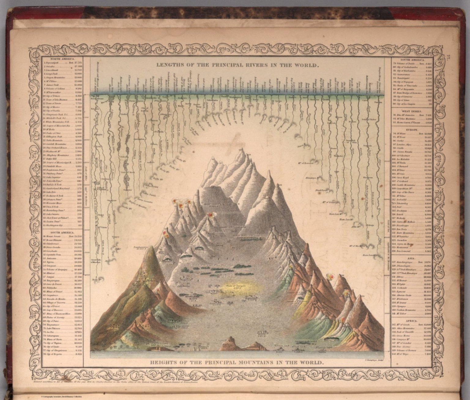
19. Lengths of the Principal Rivers in the World. Heights of the Principal Mountains in the World. F. Humphrys, Sculpt. Entered according to Act of Congress in the year 1856 by Charles Desilver in the Clerk's office if the District Court of the Eastern District of Pennsylvania. (to accompany) A New Universal Atlas Containing Maps of the various Empires, Kingdoms, States and Republics Of The World. 1859.
20. A New Map of Germany. By J.H. Young. J.L. Hazzard, Sc. Entered according to Act of Congress in the year 1859 by Charles Desilver in the Clerk's office if the District Court of the Eastern District of Pennsylvania. 55.

21. A New Map of Central America. By J.L. Hazzard. Published By Charles Desilver, 714 Chesnut Street, Philadelphia. Entered according to Act of Congress in the year 1856 by Charles Desilver in the Clerk's office if the District Court of the Eastern District of Pennsylvania. 40.

22. A New Map of the State of Wisconsin. Published By Charles Desilver, No. 714 chesnut Street, Philadelphia. Eng. by J.L. Hazzard. Entered according to Act of Congress in the year 1859 by Charles Desilver in the Clerk's office if the District Court of the Eastern District of Pennsylvania. 33.

23. A New Map of the State of North Carolina by J.L. Hazzard. Published By Charles Desilver, No. 714 Chesnut Street, Philadelphia. Entered according to Act of Congress in the year 1860 by Charles Desilver in the Clerk's office if the District Court of the Eastern District of Pennsylvania. 15.

24. A New Map of the State of South Carolinia by J.L. Hazzard. 1860. Published By Charles Desilver, No. 714 Chesnut Street, Philadelphia. Entered according to Act of Congress in the year 1860 by Charles Desilver in the Clerk's office if the District Court of the Eastern District of Pennsylvania. 19.

25. A New Map of Lousiana. By J.L. Hazzard. Published By Charles Desilver, No. 714 Chesnut Street, Philadelphia. Entered according to Act of Congress in the year 1859 by Charles Desilver in the Clerk's office if the District Court of the Eastern District of Pennsylvania. 24.

26. A New Map of Maryland and Delaware by J.L. Hazzard. Published By Charles Desilver, No. 714 Chesnut Street, Philadelphia. 1860 Entered according to Act of Congress in the year 1859 by Charles Desilver in the Clerk's office if the District Court of the Eastern District of Pennsylvania. 15.

27. A New Map of the United States of America by J.H. Young. Philadelphia, Published By Charles Desilver, No. 1229 Chesnut Street. Entered according to Act of Congress in the year 1860 by Charles Desilver in the Clerk's office if the District Court of the Eastern District of Pennsylvania. 6. Engraved by J.L. Hazzard & E. Yeager.

28. U.S. Coast Survey A.D. Bache, Superintendent Reconnaissance Of The Western Coast Of The United States, Middle Sheet, From San Francisco To Umpquah River. By the Hydrographic Party under the command of Lieut. James Alden U.S.N. Assist. Geographical Positions by G. Davidson Assistant. 1854. Corrected to 1869. Drawn by W.B. McMurtrie; Reduction for engraving by A. Lindenkohl. Engd. by G. McCoy, J. Knight, J.L Hazzard & G.B. Metzeroth. No. 602. Electrotype Copy No. 6 by G. Mathiot U.S.C.S.

29. A New Map of Germany. By J.H. Young. J.L. Hazzard, Sc. Entered according to Act of Congress in the year 1856 by Charles Desilver in the Clerk's office if the District Court of the Eastern District of Pennsylvania. 55.

30. A New Map of Central America. By J.L. Hazzard. Published By Charles Desilver, 714 Chesnut Street, Philadelphia. Entered according to Act of Congress in the year 1856 by Charles Desilver in the Clerk's office if the District Court of the Eastern District of Pennsylvania. 40.

31. A New Map of the State of Wisconsin. Published By Charles Desilver, No. 714 Chestnut Street, Philadelphia. Eng. by J.L. Hazzard. Entered according to Act of Congress in the year 1856 by Charles Desilver in the Clerk's office if the District Court of the Eastern District of Pennsylvania. 33.

32. A New Map of Lousiana. By J.L. Hazzard. Published By Charles Desilver, No. 714 Chestnut Street, Philadelphia. Entered according to Act of Congress in the year 1857 by Charles Desilver in the Clerk's office if the District Court of the Eastern District of Pennsylvania. 24.

33. A New Map of the State of South Carolinia by J.L. Hazzard. Published By Charles Desilver, No. 714 Chestnut Street, Philadelphia. Entered according to Act of Congress in the year 1856 by Charles Desilver in the Clerk's office if the District Court of the Eastern District of Pennsylvania. 19.

34. A New Map of the State of North Carolina by J.L. Hazzard. Published By Charles Desilver, No. 714 Chestnut Street, Philadelphia. Entered according to Act of Congress in the year 185? by Charles Desilver in the Clerk's office if the District Court of the Eastern District of Pennsylvania. 15.

35. A New Map of Maryland and Delaware by J.L. Hazzard. Published By Charles Desilver, No. 714 Chestnut Street, Philadelphia. Entered according to Act of Congress in the year 1856 by Charles Desilver in the Clerk's office if the District Court of the Eastern District of Pennsylvania. 15.

36. A New Map of the United States of America by J.H. Young. Philadelphia, Published By Charles Desilver, No. 714 Chestnut Street. Entered according to Act of Congress in the year 1856 by Charles Desilver in the Clerk's office if the District Court of the Eastern District of Pennsylvania. 6. Engraved by J.L. Hazzard & E. Yeager.

37. (Covers to) A New Map Of The United States of America By J.H. Young. Philadelphia Published By Charles DeSilver 251 Market St. 1857. Entered ... 1856 by Charles Desilver ... Pennsylvania. Engraved by J.L Hazzard & E. Yeager. (inset) Gold Region Of California. (inset) District Of Columbia.

38. A New Map Of The United States of America By J.H. Young. Philadelphia Published By Charles DeSilver 251 Market St. 1857. Entered ... 1856 by Charles Desilver ... Pennsylvania. Engraved by J.L Hazzard & E. Yeager. (inset) Gold Region Of California. (inset) District Of Columbia.

39. Map of Africa from the latest Authorities. Published by Cowperthwait & Co., No. 253 Market Street Philadelphia. Entered ... 1850 by Thomas Cowperthwait & Co., ... Pennsylvania. (inset) Map of Republic of Liberia from Gurley's Report, Made to the Senate of the United States, 1850.

40. Turkey in Asia. Entered ... 1850 by Thomas Cowperthwait & Co., ... Pennsylvania. (inset map) Environs of Constantinople.

41. China. Entered ... 1850 by Thomas Cowperthwait & Co., ... Pennsylvania.

42. Egypt &c. Entered ... 1850 by Thomas Cowperthwait & Co., ... Pennsylvania. (inset map) Nubia, (upper reaches of the Nile in Egypt and Sudan).

43. Hindoostan. Entered ... 1850 by Thomas Cowperthwait & Co., ... Pennsylvania. (inset map) Delta of Ganges.

44. The Pacific Ocean Including Oceanica with its several Divisions, Islands, Groups &c. Entered ... 1850 by Thomas Cowperthwait & Co., ... Pennsylvania.

45. Greece. Entered ... 1850 by Thomas Cowperthwait & Co., ... Pennsylvania. (inset map) Candia.

46. Palestine & Adjacent Countires. Published by Cowperthwait & Co., No. 253 Market Street Philadelphia. Entered ... 1850 by Thomas Cowperthwait & Co., ... Pennsylvania. (inset map) Environs of Jerusalem.

47. Persia, Arabia &c. Entered ... 1850 by Thomas Cowperthwait & Co., ... Pennsylvania.

48. Map of Turkey in Europe. With Ionian Islands. Entered ... 1850 by Thomas Cowperthwait & Co., ... Pennsylvania.

49. Russia in Asia and Tartary. Entered ... 1850 by Thomas Cowperthwait & Co., ... Pennsylvania. (inset map) Western part of Russia.

50. Kingdom of Sardinia. Entered ... 1850 by Thomas Cowperthwait & Co., ... Pennsylvania. (inset map) island of Sardinia.

Catalog
Books, media, physical & digital resources
Discovery Service for Jio Institute Digital Library
For full access to our library's resources, please sign in.