377 results on '"Young, J.H."'
Search Results

2. Map Of The States Of North Carolina South Carolina and Georgia. Philadelphia: Published by S. Augustus Mitchell. 1841. Sold By Mitchell & Hinman No. 6 North Fifth Street. Entered ... 1835, by S. Augustus Mitchell ... Pennsylvania. Engraved by J.H. Young. (inset) Vicinity Of Charleston.

3. (Covers to) Map Of The States Of North Carolina South Carolina and Georgia. Philadelphia: Published by S. Augustus Mitchell. 1836. Sold By Mitchell & Hinman No. 6 North Fifth Street. Entered ... 1835, by S. Augustus Mitchell ... Pennsylvania. Engraved by J.H. Young. (inset) Vicinity Of Charleston.

4. Map of the West Coast of Africa, from Sierra Leone to Cape Palmas: including the Colony of Liberia: Compiled chiefly from the surveys and observations of the late Revd. J. Ashmun. Published by A. Finley, at his Map Establishment Philada. J.H. Young Sc. (to accompany) A new general atlas, comprising a complete set of maps, representing the grand divisions of the globe ... 1836.

5. The tourist's pocket map of the State of Illinois : exhibiting its internal improvements, road distances & e. By J.H. Young. Philadelphia: Published by S. Augustus Mitchell. 1834. Illinois : One hundred years ago. Copyright T.N.T. Co. 1934. Illustrated by William Mark Young. (inset) Map of the Lead Mine region. Chicago Sunday Tribune, the world's greatest newspaper. In honor of Mother's Day next Sunday : three paintings by Mary Cassatt.

6. A New Map of Germany. 55. By J.H. Young. J.L. Hazzard, Sc. Entered ... 1856, by Charles Desilver ... Pennsylvania. (to accompany) A New Universal Atlas Containing Maps of the various Empires, Kingdoms, States and Republics Of The World.

7. Map of Europe Compiled from the Latest Authorities. 47-48. By J.H. Young. Philadelphia Published by Charles Desilver, No. 714 Chesnut St. Entered ... 1859, by Charles Desilver ... Pennsylvania. (to accompany) A New Universal Atlas Containing Maps of the various Empires, Kingdoms, States and Republics Of The World.

8. A New Map of the State of Indiana : Exhibiting Its Internal Improvements, Roads, Distances, &c. By J.H. Young. Philadelphia: 31. Published By Charles Desilver, No. 714 Chestnut St. Entered ... 1859, by Charles Desilver ... Pennsylvania. (to accompany) A New Universal Atlas Containing Maps of the various Empires, Kingdoms, States and Republics Of The World.

9. Map of The State of Texas from the latest authorities. 25. By J.H. Young. Published By Charles Desilver, Philadelphia. 1859. Eng. by J.L. Hazzard. Entered ... 1856, by Charles Desilver ... Pennsylvania. (insets) Northern Texas (panhandle). (and) Galveston Bay. (to accompany) A New Universal Atlas Containing Maps of the various Empires, Kingdoms, States and Republics Of The World.

10. A New Map of the State of Georgia Exhibiting Its Internal Improvements, Roads, Distances &c. By J.H. Young. Philadelphia, Published By Charles Desilver, No. 714 Chestnut St. 20. Entered ... 1859, by Charles Desilver ... Pennsylvania. (to accompany) A New Universal Atlas Containing Maps of the various Empires, Kingdoms, States and Republics Of The World.

11. A New Map of the state of Pennsylvania: Exhibiting its internal improvements. Roads, Distances, &c. By J.H. Young. Philadelphia, Published by Charles Desilver, No. 714 Chestnut St. 1959. 14. Entered ... 1859, by Charles Desilver ... Pennsylvania. (insets) Lehigh and Schuyland Coal Regions. (and) Vicinity of Philadelphia. (to accompany) A New Universal Atlas Containing Maps of the various Empires, Kingdoms, States and Republics Of The World.

12. A New Map of the State of Virginia : Exhibiting its internal improvements, Road Distances &c. by J.H. Young. Philadelphia: Published by Charles Desilver, No. 714 Chestnut St. 17. Entered ... 1859, by Charles Desilver ... Pennsylvania. (inset) District of Columbia. (to accompany) A New Universal Atlas Containing Maps of the various Empires, Kingdoms, States and Republics Of The World.

13. (Contents to) A New Universal Atlas Containing Maps of the various Empires, Kingdoms, States and Republics Of The World. With a special map of each of the United States, Plans of Cities &c. Comprehended in eighty one sheets and forming a series of One Hundred And Forty Five Maps, Plans And Sections ... Philadelphia, Charles Desilver, 714 Chesnut Street. 1859. Entered ... 1859, by Charles Desilver ... Pennsylvania. (title page by) J. Knight Sc.

14. (Title Page to) A New Universal Atlas Containing Maps of the various Empires, Kingdoms, States and Republics Of The World. With a special map of each of the United States, Plans of Cities &c. Comprehended in eighty one sheets and forming a series of One Hundred And Forty Five Maps, Plans And Sections ... Philadelphia, Charles Desilver, 714 Chesnut Street. 1859. Entered ... 1859, by Charles Desilver ... Pennsylvania. (title page by) J. Knight Sc.

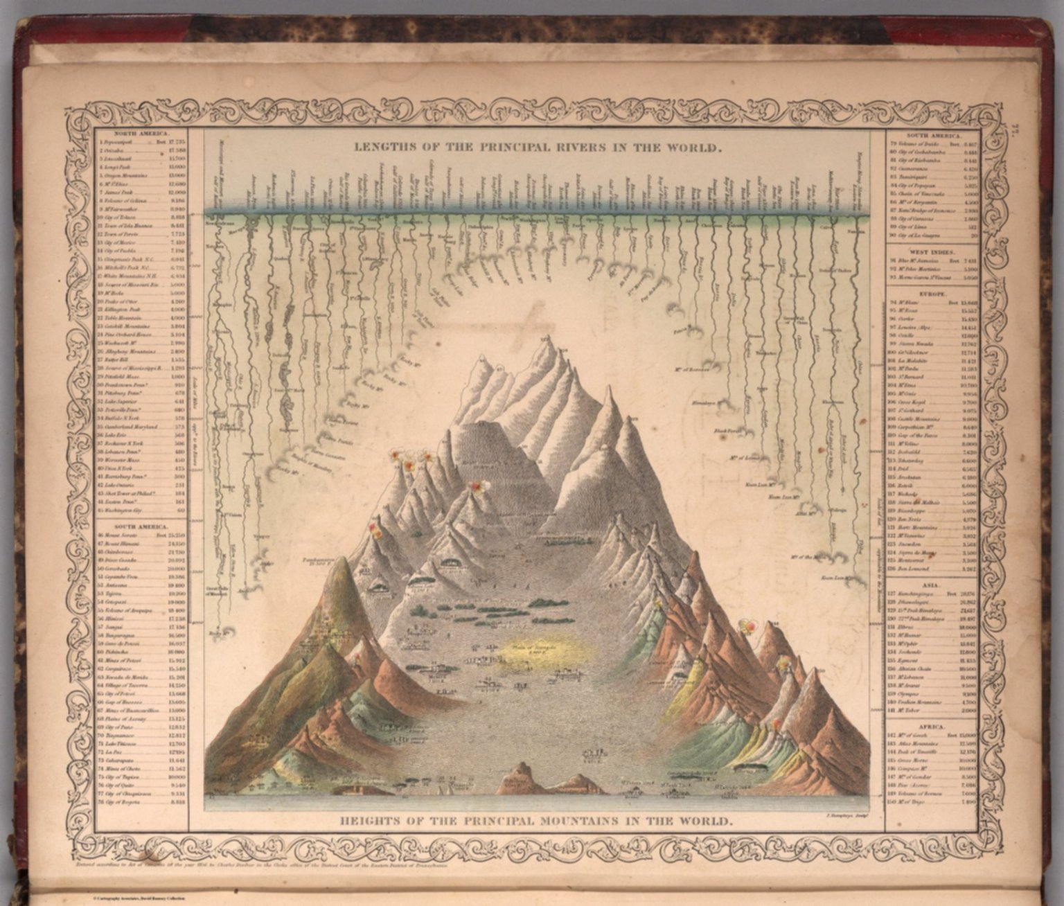
15. Lengths of the Principal Rivers in the World. Heights of the Principal Mountains in the World. F. Humphrys, Sculpt. Entered according to Act of Congress in the year 1856 by Charles Desilver in the Clerk's office if the District Court of the Eastern District of Pennsylvania. (to accompany) A New Universal Atlas Containing Maps of the various Empires, Kingdoms, States and Republics Of The World. 1859.
16. The Empire State, New York with its Counties, Towns, Cities, Villages: Internal Improvements &c. Published by S. Augustus Mitchell, No. 8 1/2 South Seventh Street; Philadelphia. 1841. Drawn & Engraved by J.H. Young.

17. (Covers to) The Empire State, New York with its Counties, Towns, Cities, Villages: Internal Improvements &c. Published by S. Augustus Mitchell, No. 8 1/2 South Seventh Street; Philadelphia. 1841. Drawn & Engraved by J.H. Young.

18. A New Map of Germany. By J.H. Young. J.L. Hazzard, Sc. Entered according to Act of Congress in the year 1859 by Charles Desilver in the Clerk's office if the District Court of the Eastern District of Pennsylvania. 55.

19. Map of the United States Partly From New Surveys Dedicated to the Citizens thereof, by their humble servant Chas. Varle Engineer and Geographer 1817. Entered according to Act of Congress. Published by the Author, Baltimore. Engrav'd by J.H. Young Philada. (with) inset Map of North America. (with) inset Physical Sections from 'Washington City to Wheeling and from thence to the mouth of Columbia river' and from the 'Pacific Ocean to the Gulf of Mexico.'

20. Map of Texas from the most recent authorities, Philadelphia. Published by C.S. Williams, N.E. Corner of Market & 7th Streets. 1845. Entered ...1845 by C.S. Williams ... Pennsylvania. Drawn & Engraved by J.H. Young.

21. New Jersey. Philadelphia Published by A. Finley 1834 Engraved by J.H. Young.

22. (Covers to) New Jersey. Philadelphia Published by A. Finley 1834 Engraved by J.H. Young.

23. A New Map Of Texas, With The Contiguous American & Mexican States by J.H. Young. Philadelphia: Published by S. Augustus Mitchell. 1836. Sold by Mitchell & Hinman No. 6 North Fifth Street. Engraved by J.H. Young. Entered ... 1835 by S. Augustus Mitchell ... Pennsylvania.

24. Pennsylvania. Philada. Published by A. Finley, 1832. J.H. Young Sc.

25. (Covers to) Pennsylvania. Philada. Published by A. Finley, 1832. J.H. Young Sc.

26. Mitchell's National Map of the American Republic Or United States Of North America ... 1846. Drawn by J.H. Young. Engraved by J.H. Brightly. Entered ... 1846, by S. Augustus Mitchell ... Pennsylvania. (with 4 inset maps). (with) A Route-Book, Adapted To Mitchell's National Map Of The American Republic; Comprising Tables Of The Principal Rail-Road, Steam-Boat And Stage Routes, Throughout The United States. Philadelphia: S. Augustus Mitchell, N.E. Cor. Market And Seventh Sts. 1847. (on verso) Entered ... 1846, by S. Augustus Mitchell ... Pennsylvania. Stereotyped by J. Fagan. Printed by Kay & Brother.

27. (Covers to) A Route-Book, Adapted To Mitchell's National Map Of The American Republic; Comprising Tables Of The Principal Rail-Road, Steam-Boat And Stage Routes, Throughout The United States. Philadelphia: S. Augustus Mitchell, N.E. Cor. Market And Seventh Sts. 1847. (on verso) Entered ... 1846, by S. Augustus Mitchell ... Pennsylvania. Stereotyped by J. Fagan. Printed by Kay & Brother. (with) Mitchell's National Map of the American Republic Or United States Of North America ... 1846. Drawn by J.H. Young. Engraved by J.H. Brightly. Entered ... 1846, by S. Augustus Mitchell ... Pennsylvania. (with 4 inset maps).

28. (Title Page to) A Route-Book, Adapted To Mitchell's National Map Of The American Republic; Comprising Tables Of The Principal Rail-Road, Steam-Boat And Stage Routes, Throughout The United States. Philadelphia: S. Augustus Mitchell, N.E. Cor. Market And Seventh Sts. 1847. (on verso) Entered ... 1846, by S. Augustus Mitchell ... Pennsylvania. Stereotyped by J. Fagan. Printed by Kay & Brother. (with) Mitchell's National Map of the American Republic Or United States Of North America ... 1846. Drawn by J.H. Young. Engraved by J.H. Brightly. Entered ... 1846, by S. Augustus Mitchell ... Pennsylvania. (with 4 inset maps).

29. The Tourist's Pocket Map Of Michigan Exhibiting Its Internal Improvements Roads Distances &c. by J.H. Young. Philadelphia: Published By S. Augustus Mitchell. 1835. Sold By Mitchell & Hinman No. 6 North Fifth Street. Entered ... 1834 by S. Augustus Mitchell ... Pennsylvania. Engraved by J.H. Young.

30. The Tourist's Pocket Map Of The State Of Tennessee Exhibiting Its Internal Improvements Roads Distances &c. by J.H. Young. Philadelphia: Published By S. Augustus Mitchell. 1839. Sold by Thomas, Cowperthwait & Co. No. 253 Market Street. Entered ... 1834 by S. Augustus Mitchell ... Pennsylvania. Engraved by J.H. Young. (inset) Vicinity Of Nashville. (inset) Vicinity Of Knoxville.

31. (Covers to) The Tourist's Pocket Map Of The State Of Tennessee Exhibiting Its Internal Improvements Roads Distances &c. by J.H. Young. Philadelphia: Published By S. Augustus Mitchell. 1839. Sold by Thomas, Cowperthwait & Co. No. 253 Market Street. Entered ... 1834 by S. Augustus Mitchell ... Pennsylvania. Engraved by J.H. Young. (inset) Vicinity Of Nashville. (inset) Vicinity Of Knoxville.

32. (Covers to) The Tourist's Pocket Map Of Michigan Exhibiting Its Internal Improvements Roads Distances &c. by J.H. Young. Philadelphia: Published By S. Augustus Mitchell. 1835. Sold By Mitchell & Hinman No. 6 North Fifth Street. Entered ... 1834 by S. Augustus Mitchell ... Pennsylvania. Engraved by J.H. Young.

33. (Covers to) New Jersey. Sold By Thomas, Cowperthwait & Co. No. 253 Market Street, Philada. 1845. Engraved by J.H. Young.

34. New Jersey. Sold By Thomas, Cowperthwait & Co. No. 253 Market Street, Philada. 1845. Engraved by J.H. Young.

35. Map of Oceanica. Engraved to Illustrate Mitchell's School and Family Geography. No. 16. Engraved by J.H. Young. Entered ... 1839, by S. Augustus Mitchell ... Connecticut.

36. Map of Asia. Engraved to Illustrate Mitchell's School and Family Geography. No. 12. (with) Map of Palestine or the Holy Land. No. 13. Engraved by J.H. Young. Entered ... 1839, by S. Augustus Mitchell ... Connecticut.

37. Map of Europe. Engraved to Illustrate Mitchell's School and Family Geography. No. 11. Engraved by J.H. Young. Entered ... 1839, by S. Augustus Mitchell ... Connecticut.

38. Map of Africa. Engraved to Illustrate Mitchell's School and Family Geography. No. 14. (with) Map of Liberia. No. 15. Engraved by J.H. Young. Entered ... 1839, by S. Augustus Mitchell ... Connecticut.

39. Map of the New England or Eastern States. Engraved to Illustrate Mitchell's School and Family Geography. No. 6. Engraved by J.H. Young. Entered ... 1839, by S. Augustus Mitchell ... Connecticut.

40. Map of South America. Engraved to Illustrate Mitchell's School and Family Geography. No. 10. Engraved by J.H. Young. Entered ... 1839, by S. Augustus Mitchell ... Connecticut.

41. Map of the Middle States. Engraved to Illustrate Mitchell's School and Family Geography. No. 7. Engraved by J.H. Young. Entered ... 1839, by S. Augustus Mitchell ... Connecticut.

42. The World on an Equatorial Projection. No. 1. Map of the Eastern & Western Hemispheres. (with) The World on a Polar Projection. No 2. Map of the Northern & Southern Hemispheres. Engraved by J.H. Young. Entered ... 1839, by S. Augustus Mitchell ... Connecticut.

43. Map of North America Engraved to Illustrate Mitchell's School and Family Geography. No. 3. Engraved by J.H. Young. Entered ... 1839, by S. Augustus Mitchell ... Connecticut.

44. (Covers to) The Tourist's Pocket Map Of The State Of Indiana Exhibiting Its Internal Improvements Roads Distances &c. By J.H. Young. Philadelphia: Published by S. Augustus Mitchell. 1834. Entered ... 1834 ... Pennsylvania. Engraved by J.H. Young & F. Dankworth. (inset) Population of the State of Indiana...1930.

45. (Covers to) Map of the States Of Ohio, Indiana And Illinois with the settled part of Michigan. Published by S. Augustus Mitchell Philadelphia: 1834. Sold by Mitchell & Hinman No. 6 North 5th St. Entered ... 1834 by S. Augustus Mitchell ... Pennsylvania. Engraved by J.H. Young. (inset) Lead Region East of the Mississippi River. (inset) Falls Of Ohio. (inset) Vicinity Of Cincinnati. (inset) Vicinity Of Detroit.

46. The Tourist's Pocket Map Of The State Of Indiana Exhibiting Its Internal Improvements Roads Distances &c. By J.H. Young. Philadelphia: Published by S. Augustus Mitchell. 1834. Entered ... 1834 ... Pennsylvania. Engraved by J.H. Young & F. Dankworth. (inset) Population of the State of Indiana...1930.

47. Map of the States Of Ohio, Indiana And Illinois with the settled part of Michigan. Published by S. Augustus Mitchell Philadelphia: 1834. Sold by Mitchell & Hinman No. 6 North 5th St. Entered ... 1834 by S. Augustus Mitchell ... Pennsylvania. Engraved by J.H. Young. (inset) Lead Region East of the Mississippi River. (inset) Falls Of Ohio. (inset) Vicinity Of Cincinnati. (inset) Vicinity Of Detroit.

48. Map Of The State Of Maine With The Province Of New Brunswick By Moses Greenleaf. Engraved by J.H. Young & F. Dankworth, Philadelphia. Third Edition. Carefully revised and corrected from the latest official authorities. Jany. 1844. Entered ... 29th day of February 1828 by Moses Greenleaf ... Maine. (inset map of Nova Scotia and Gulf of St. Lawrence).

49. Map of the West Coast Of Africa, from Sierra Leone to Cape Palmas: including the Colony Of Liberia: Compiled chiefly from the Surveys and Observations Of The Late Revd. J. Ashmun. Published by A. Finley, at his Map Establishment Philada. 1831. J.H. Young Sc. (inset) Plan Of The Town Of Monrovia.

50. Florida. 1831. Published by A. Finley Philadelphia. J.H. Young Sc. (inset) Plan Of Tallahassee. (inset) Plan Of Pensacola.

Catalog
Books, media, physical & digital resources
Discovery Service for Jio Institute Digital Library
For full access to our library's resources, please sign in.